top of page
GROTON TOWN CENTER MASTER PLAN THE HISTORIC TOWN CENTER, AND THE ROLE OF 134 MAIN STREET GROTON, MA
Circulation Diagrams for small increments of growth and development over the long-term to knit together a cohesive Town Center (Overlay District) in Groton, MA.
Produced by the Moonlight Studio: Tim Hess-Studio Director
In support of the Town Center Overlay District Design Review Committee: Tim Hess, chair
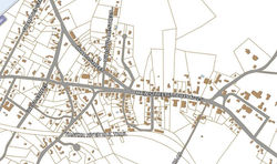
 The Groton Center bottleneck |  Groton Town Center ParcelsTown center parcels, buildings and public roads. Note the relatively narrow width and great depth of several parcels above Main Street here. |
|---|---|
 From the (July 2011) final application for 134 Main Street, "Boynton Meadow at Gibbet Hill". A cul-de-sac and 18 condominiums. The first floor at the old Kilbridge's building would remain retail space. |  Together with some of the more significant private drives and parking lots, the Roads existing in 2011 are traced over a faint background of an imagined future Groton Town Center map below. |
 Wetlands, and the parcel at 134 Main Street (Kilbridge's), Groton. By Town Meeting vote in Spring 2011, this parcel was added to the Station Avenue Overlay District, and the SOAD was renamed The "Town Center Overlay District", or "TCOD". |  Instead of the proposed cul-de-sac, this kind of circulation diagram for the 134 parcel would preserve opportunities for neighboring parcels to enrich Groton's Town Center with the kind of civic vitality the state's 43D program and Groton's TCOD are intended to foster. Continue flipping through this sequence of images to see how Groton's Town Center could develop over time. |
 In Groton, Main Street is also MA119 and MA225. Land is cheaper to the left (Northwest) and jobs more plentiful to the right (Southeast). Through the Town Center, a tide of 22,000 cars washes from left to right Every morning, and right to left every evening. The 2010 census counted the town population at 10,646 (people, that is. Not sure how many cars live here). — in Groton, Massachusetts. |  From the left (NW) Hollis Street and Pleasant Street feed into Main Street. For a length of 1600ft or about five football fields, Groton Center is pinched (between Half Moon Swamp and the Broadmeadow) to a single road before it is relieved at Lowell Rd/rte40 and Broadmeadow Road. — in Groton, Massachusetts. |
 Town Center Northeast 2011Between the Boutwell School and Petapawag Place, landlocked property has been connected to Main Street by individual roads and drives at Willowdale Road, Mayfield Drive, Kilbridge's The Old Groton Inn, and Lawrence Academy's Waters House. — in Groton, Massachusetts. |  Town Center Northeast 2012?Development at 134 Main Street should anticipate and enable future connection to abutting parcels. Those immediately left and right are both for sale as of 08.13.2011. — in Groton, Massachusetts. |
 Town Center Northeast 2014?Future development at 128 Main (The Old Groton Inn), would then have the opportunity to cooperate with 134 Main, and a circuit could be completed. (Like the circuit made by Court Street and Station Avenue.) |  Town Center Northeast 2016?Left (NW) of 134/Kilbridge's, the next parcel presents the best opportunity to stitch the top(NE) and bottom (SW) sides of the Town Center together across Main Street. Growing from the NOA Gifts side access to The Prescott School, a new Prescott Street would be a good candidate for retail and commercial development. |
 Town Center Northeast 2018?If, like the developer that proposes to purchase 134 Main, future owners of adjacent parcels seek to maximize profits by reaching into the depth of their narrow parcels, they should be connected not just back to Main Street, but to each other - and by public circulation, not shared driveways. Shown here, we image a "Hockey Pond Road" and a "Waters House Road" stitching together the evolving Town Center. A new conservation boardwalk and dog park just beyond "Half-Moon Drive" with views! |  Town Center Northeast, 2020?And what if the new civic space of the TCOD's first few projects proves successful, and what if that success drives an increase in development pressure? A new "Half-Moon Drive" could span from School Street and Legion Common across Willowdale, Mayfield, "Hockey Pond Road", "Town Center Park Place", "Prescott Street", "Kilbridge Road" and "Gibbet Barn Road" to Lowell Road/rte 40. |
 Town Center Southwest, 2011.(The much-studied Station Avenue District, today.) |  Town Center Southwest, as planned; The former Station Avenue Overlay District. A circulation diagram of the district at maturity, as envisioned by the 43D's published Design Guidelines. — in Groton, Massachusetts. |
 Town Center Southwest 2016?!A phase beyond the evolution imagined by the 43D TCOD Design Guidelines. New vehicular connections behind Prescott, Moison's, the DD Plaza. More robust recreational and educational engagement at the Broadmeadow. |  Town Center Southwest 2030?And a second phase beyond the Design Guidelines. This much improvement doesn't seem likely for another generation or more. |
 Groton Town Center, 2030?! |  Groton Town Center 2030?! 2040?!Represented in orange, new roads to the Northeast of Main Street suggest a public way and opportunities for civic ammenities such as parkspace (a Senior Center? a Teen Center? in addition to passive and active recreation space) knitting Half-Moon Swamp and Gibbet Hill to the Historic Spine of Main Street. New roads would create valuable frontage for the presently narrow & deep parcels (such as those at Kilbridge's and the Old Groton Inn). |
 Groton Town Center Northeast.July 30, 2011 scheme. |  July 30, 2011 scheme. Detail. |
 This official zoning map shows "underlying" zoning information. (This is the default zoning to which overlay district properties are subject if they choose not develop under 43d and the Design Guideline.) — in Groton, Massachusetts. |  The 134/Kilbridge's 'porkchop'-shapeThe parcel is at approximately 2 o'clock in this image. Adding to 134 the dark cross-hatching that identifies the former SAOD, one can see the present TCOD. The option to develop under the 43d TCOD Design Guideline should be offered to several other parcels - maybe everything on both sides of Main Street between Donelan's and the First Parish Church? As an outlier to the otherwise contiguous district, 134 Main can do little to contribute to the district withou |
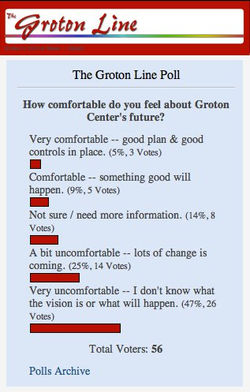
 This official Concept Plan of the former SAOD shows potential building footprints / envelopes in orange, public open space and park space in green, and suggests circulation improvements from Station Avenue to Broadmeadow Road, as well as to Court Street and Adams Avenue beyond. |  40 / 56 surveyed feel uncomfortable about Groton Center's future. |
 This project is nearly complete in fall 2011, just outside West Concord, MA. The TCOD Design Review Committee suggested the 134 team adopt some of the strategies that are so effective here. The 3-bedroom houses have footprints of 24 ft x 48 ft. http://www.concordriverwalk.com/ — in West Concord, Massachusetts. |
bottom of page


